
The U.S. Army Corps of Engineers on Jan. 26 released a draft plan for an estimated $13.6 billion project to protect a 7.5-mile stretch of San Francisco’s waterfront from flooding coastal
The draft feasibility report and environmental review is the result of a years-long collaboration between the Corps, the city and the Port of San Francisco. Col. James Handura, commander of the Corps’ South Pacific Division, said during a news conference that the tentatively selected plan was developed using elements of seven alternatives that the team released for public review in 2022 as part of the larger San Francisco Coastal Flood Study. .
The plan was developed using the Corps’ traditional economic analysis, but Handura said it also considers factors such as environmental justice, social and economic equity and impacts on vulnerable populations.
“This is not just a step forward for San Francisco, it’s a step forward for the Corps of Engineers,” he said. “What we’re doing here in the bay will be a model for other projects.”
The main objective of the study is to identify the risk of flooding for the San Francisco coastline from major coastal storms and extreme high tide events. According to the Corps, an estimated $22 billion in public sector assets are at risk, including the main transport infrastructure and the financial district of the city.
The Corps aims to complete the work by 2040. The tentatively selected plan is scaled to work under the initial risk and to be adaptable to the risk of higher relative sea level change in the future with smaller projects after 50 years. Tracking would be used to determine if a different time is needed. With large increases in sea level rise expected over the next few decades, the Corps estimates that eventual costs could reach an additional $11.6 billion in current dollars for additional work, such as raising more seawalls and levees to protect -se of the rise of the sea.
“In a way, we’re planting a tree that will be enjoyed by future generations,” former House Speaker Nancy Pelosi said at the news conference. “But we owe it to them to make sure we get it right.”
The draft is now subject to a 60-day public comment period, after which Handura said the Corps will revise it based on feedback, further analysis and policy review. He expects the final report and recommended plan to be submitted to Congress for consideration in 2026.
 Map by CMG Landscape Architecture and Urban Study SITELAB/courtesy of the US Army Corps of Engineers
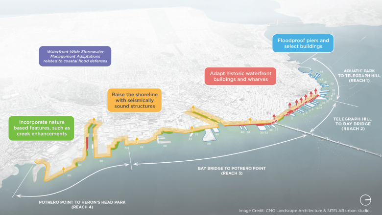
The provisional plan divides the promenade into four sections. Ranges 1 and 2 cover the Embarcadero, a historic waterfront neighborhood along a more than 100-year-old seawall. From Pier 27-29 to the San Francisco-Oakland Bay Bridge, the shoreline would rise between 3.5 feet and 7.5 feet. This may require the reconstruction of Embarcadero Road, depending on the final design. The plan also calls for building a 2-foot-high concrete curb around the perimeter of the piers, replacing some piers, elevating some buildings on the piers north of the Bay Bridge, and Fisherman’s Wharf stormwater management infrastructure.
The Reach 3 plan, which covers the area around Mission Creek and Mission Bay, includes building walls between 1.5 and 4.5 feet high, creating natural shorelines or embankments, and reconstruction of bulkhead walls and piers. Concrete curbs would also be built around the piers in this span, and deployable enclosure structures would be installed on the north and south abutments of the Third and Fourth Street bridges. The naturalized coasts would be improved. Some Pier 68/70 shipyard buildings would be removed or shoreline features would have to be adjusted.
Access the 4 from Islais Creek and the Bayview area. According to the plan, the shorelines would be elevated with a combination of naturalized or embanked shorelines, flood walls and curb extensions between 2.5 feet and 5.5 feet high. Concrete curbs would be installed around some piers. Nature-based features would be incorporated into Warm Water Cove and along parts of the Islais Creek bank. Lockable structures would be installed on the abutments of the Illinois Street Bridge.